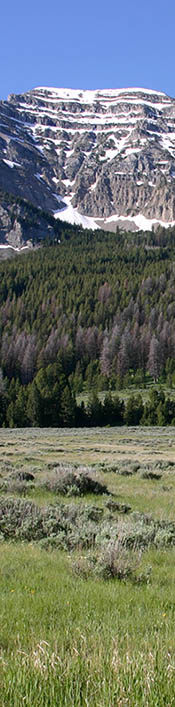
Stratification deals with the physical contrasts or layers observed in rock types, as in those visible on the north slopes of the Centennial Mountains. Such layers can occur both vertically - in layering or bedding of varying rock type - and laterally - reflecting changing environments of rock material deposition. Elements of stratigraphy involve understanding how certain geometric relationships between rock layers arise and what these geometries mean in terms of the depositional environment. Geologists have found that in an undeformed stratigraphic sequence, the oldest chronological strata occur at the base of the mountain.
Local Stratigraphy of Centennial Mountains
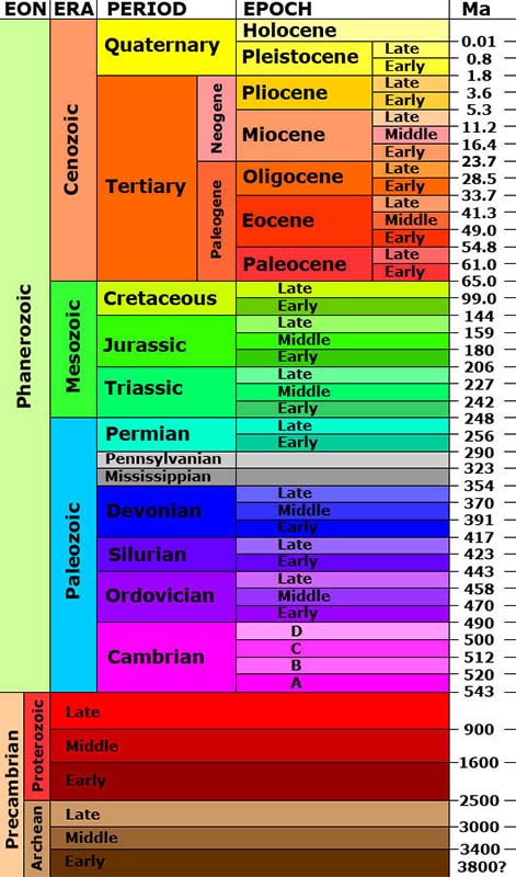
Precambrian (prior to 500 million years ago): The Precambrian basement rocks of the Centennial Mountains are primarily metamorphic and exposed in the core of the eastern Centennial Mountains. They consist of different gneiss; Paleoproterozoic mica schist, quartzite, marble, and amphibolite.
Paleozoic (prior to 250 million years ago):
Precambrian rocks are overlain by Paleozoic rocks ranging from Middle Cambrian to Permian in age, with a composite thickness of approximately 3150 feet. The Paleozoic section comprises the north face of the easter Centennial Mountains from Odell Creek on the west to east of Hell Roaring Creek. These units are (stratigraphic order from oldest to youngest): Cambrian Flathead Sandstone, Wolsey Shale, Meagher Limestone, Park Shale, and Pilgrim Limestone; Ordovician Snowy Range and Bighorn Formations; Devonian Jefferson Dolomite; Upper Devonian to Lower Mississippian Three Forks Formation; Mississippian Madison Group; Upper Mississippian to Middle Pennsylvanian Amsden Formation; Pennsylvanian Quadrant Sandstone; and Permian Shedhorn Formation.
Mesozoic (prior to 70,000 years ago):
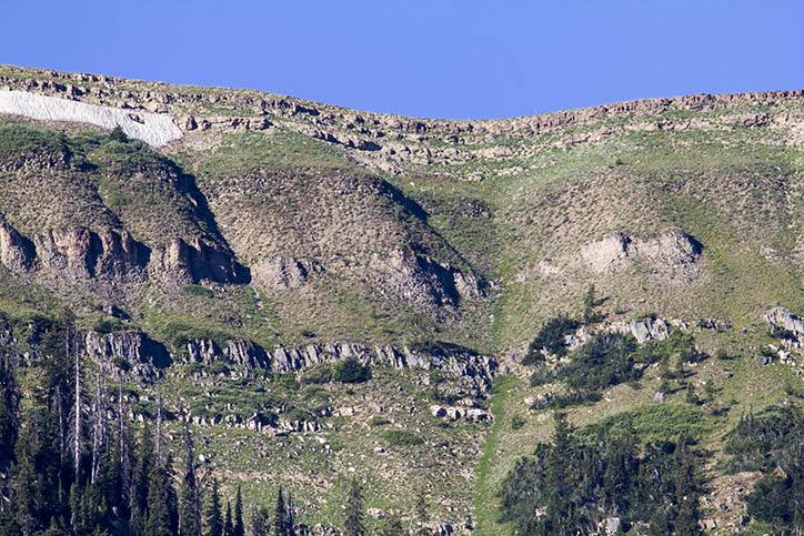
The Mesozoic rocks in the eastern Centennial Mountains are approximately 700 meters thick and are overlain by a veneer of volcanic rocks forming the south-facing dip-slope of the mountain range. Mesozoic rocks in the eastern Centennial Mountains comprise the following formations (stratigraphic order from oldest to youngest): Triassic Dinwoody and Woodside Formations; Jurassic Ellis Group and Morrison Formations; Cretaceous Kootenai; and, Thermopolis and Frontier Formations (O'Neill and Christiansen, 2004). These rocks are primarily siltstone, sandstone, marly limestone and shale forming the higher elevation dip slopes beneath the southward sloping volcanic rocks of the eastern Centennial Mountains.
The Mesozoic rocks in the eastern Centennial Mountains are older than those exposed in the western Centennial Mountains (west of the Odell Creek fault). Specifically, the Cretaceous Frontier Formation is widely exposed along the western Centennial Mountains, whereas older Cretaceous and deeper units lack exposure. The north face of the western Centennial Mountains exposes interbedded sandstones, siltstones, mudstones, carbonaceous shales and coal seams of the Frontier Formation, capped by volcanic rocks along the crest and south flank of the mountain range.
Cenozoic: (less than 70,000 years ago)
The Cenozoic volcanic rocks exposed in the eastern Centennial Mountains are (stratigraphic order from oldest to youngest): the Eocene Absaroka Volcanic Supergroup, Eocene felsic and mafic volcanic rocks, 2.1 Ma Huckleberry Ridge Tuff and the 640 ka Lava Creek Tuff. Igneous rocks in the region are mostly widespread volcanic units extending along the south flank of the mountain range from Sawtell Peak on the east to Monida on the west. Sawtell Peak is underlain by dark gray, potassium-rich, Tertiary flows and flow breccias, forming the dominant topographic feature in the eastern part of the mountain range. The volcanic rocks exposed along the crest of the eastern Centennial Mountains extend eastward and southward and are overlain by rhyolitic ash-flow tuffs of Plio-Pleistocene age, which were likely sourced from eruptions of the Yellowstone volcanic field.
This information was extracted from the paper:
SCARP ANALYSIS OF THE CENTENNIAL NORMAL FAULT, BEAVERHEAD
COUNTY, MONTANA AND FREMONT COUNTY, IDAHO
by
Falene Elizabeth Petrik
A thesis submitted in partial fulfillment
of the requirements for the degree
of
Master of Science
in
Earth Sciences
MONTANA STATE UNIVERSITY
Bozeman, Montana
April 2008
Further references to identification of specific rocks were removed from this discussion for ease of reading and can be seen in the above referenced paper.
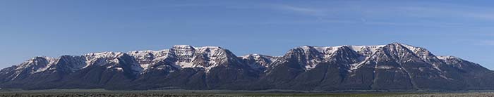
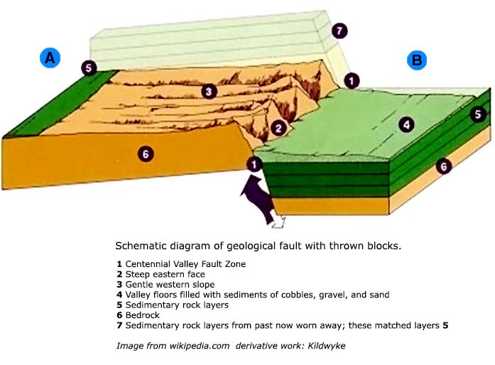
Our ability to see this stratification results from the tilting of ancient bedrock and the exposure of the uplifted portion. (see
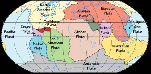
diagram) We know that the surface of the earth is made up of plates of rock known as tectonic plates (see
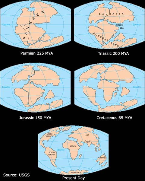
diagram) and that they have been moving around the surface of the earth for billions of years. The earth exposed along the Centennial Mountains were most likely formed far away from this latitude and longitude. In geologic timeframes, the surface of the earth never stays in one place for long. Thus, the layering that you see along the fronts of Taylor
 and Sheep
mountains tell a story of extremely ancient oceans, deserts and mountains that may have formed far from this latitude and longitude. (see
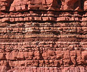
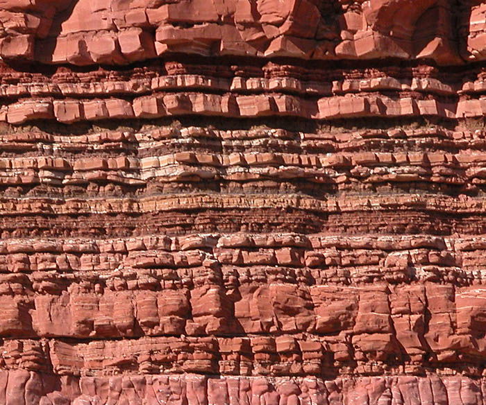
diagram) Sedimentation from ancient oceans, wind swept deserts and pressures from millions of years of being UNDER so much rock and sediment flatten and stratify the rock to become the layers we see here. Each layer represents a different period of the earths geologic history and climate. Some layers are harder than others and erosion of the exposed rock face cause differences in the layers to become visible. (See dramatic
example at the Vermillion Cliffs in Kanab, Utah). As the earth's crust moves, it moves into different latitudes of climates, and through different epochs of global climate changes. The North American plate today is moving about 25 kilometers per million years in a southwesterly direction. From this, we can understand that when the Centennial Mountains were being formed, they were from 30 to 50 miles further northeast than now.
and Sheep
mountains tell a story of extremely ancient oceans, deserts and mountains that may have formed far from this latitude and longitude. (see
diagram) Sedimentation from ancient oceans, wind swept deserts and pressures from millions of years of being UNDER so much rock and sediment flatten and stratify the rock to become the layers we see here. Each layer represents a different period of the earths geologic history and climate. Some layers are harder than others and erosion of the exposed rock face cause differences in the layers to become visible. (See dramatic
example at the Vermillion Cliffs in Kanab, Utah). As the earth's crust moves, it moves into different latitudes of climates, and through different epochs of global climate changes. The North American plate today is moving about 25 kilometers per million years in a southwesterly direction. From this, we can understand that when the Centennial Mountains were being formed, they were from 30 to 50 miles further northeast than now.
An interesting way to view the various rock layers that have been deposited by past geologic action and that are visible at the surface is a geologic map. A geologic map of the Centennial Valley can be viewed here. (click on the map to zoom in, and move the mouse to look around) A color key is provided to interpret the various rock types. Red lines indicate the Centennial fault lines where the mountain is rising and the valley is sinking with respect to one another.
The layers we see on the front of these mountains gives character and a sense of ancient history to our Refuge. However, it is the shape of the current Centennial Range that is perhaps most interesting. We will next explore HOW the uplifting occurred on our volcanism and earthquakes page.

