
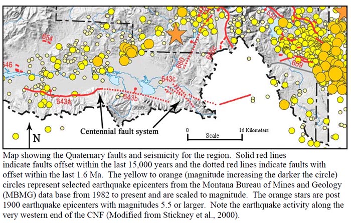
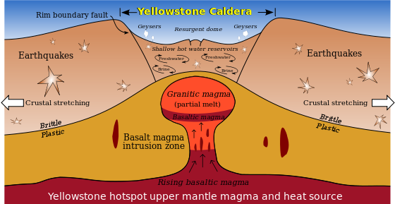
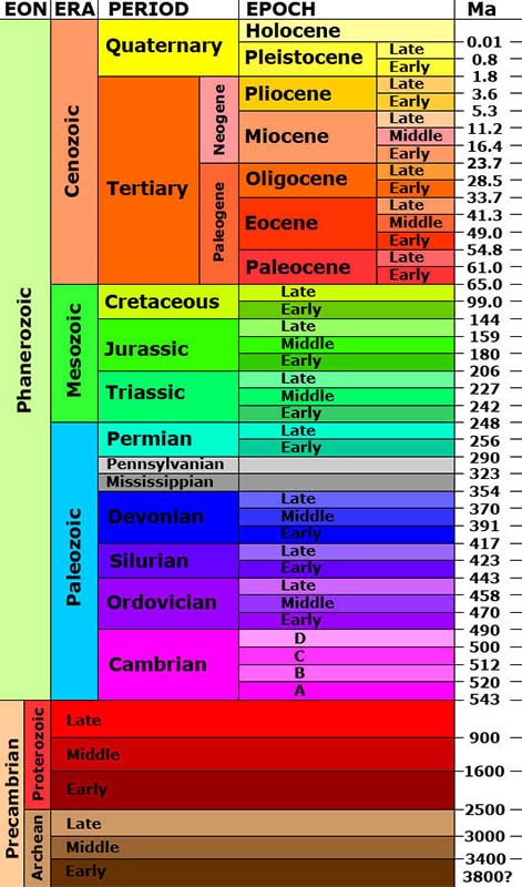
Volcanic activity is another force that contributes to mountain building. As molten rock or magma breaks through the surface of the earth, earthquakes, explosions, flowing lava, and uplifting forces can dramatically shape an area. The Centennial Mountains lie within the Intermountain Seismic Belt. This is an area of current geologic activity. (See diagram) As evident from the diagram, the Centennial Valley has not directly experienced earthquakes in the last 100 years, but it is surrounded by many areas of recent earthquake activity. However, evidence exists to show that the Centennial fault has had numerous magnitude 7+ earthquakes in the last 12,000 to 14,000 years. There have been 50 moderate-to-large (magnitude 5.5 to 7.5) earthquakes in the surrounding zone since 1900, including the 1959 Hebgen Lake quake which caused a large landslide that created Earthquake Lake in Montana (Mag=7.5) and the 1983 Borah Peak quake in Idaho (Mag = 7.3). These earthquakes often accompany mountain building as the two sides of a fault slip in relation to one another.
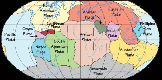
Earthquakes can be evidence of earth movement and mountain building. Mountains are most frequently created by the forces of the tectonic plates (see
diagram) moving against each other, one going beneath another, pushing up the earth's crust to form steep mountain ranges, such as the
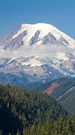
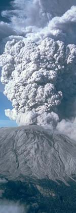
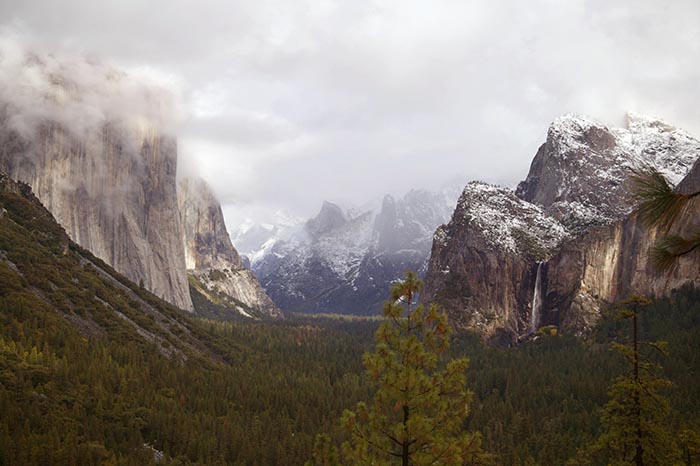
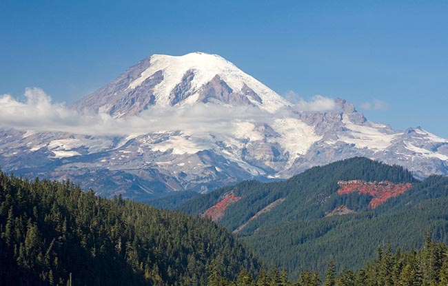
Sierra Nevada Range in California. Sometimes, mountains are created through volcanic eruptions, such as the Cascade Range, like
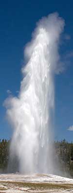
Mount Rainier in Washington State. However, here in the Centennial Valley, the movement that created the Centennial Mountain Range is thought to have resulted from pressures of a great plume of volcanic magma that has created the Yellowstone National Park and still powers the thermal pools, and geysers. This great plume (See diagram) pushes up on the overlaying crust and creates "cracks" or faults that define blocks of earth that move up or down with the pressures and subsequent earth movement.
(see
diagram) Earthquakes often happen beneath these faults as the blocks slip with regard to each other.
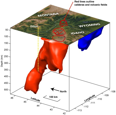
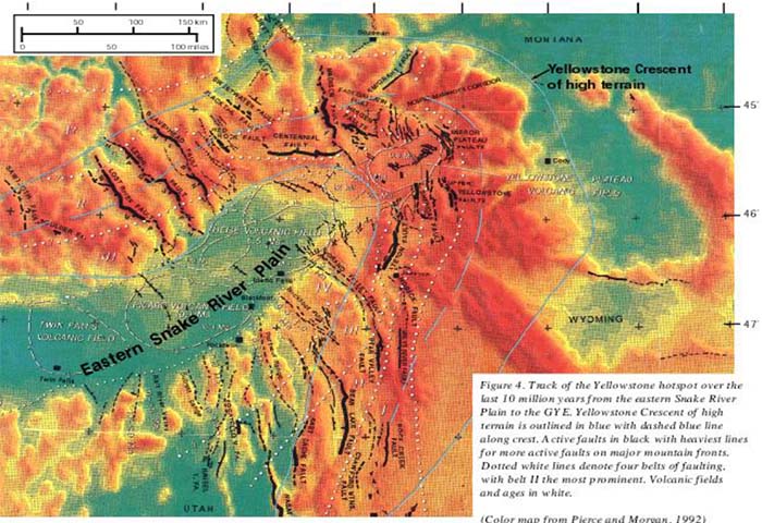
These faults are evident as the North American tectonic plate has moved southwesterly over the last 15 million years over this stationary plume or hotspot, creating volcanic fields as it breaches the surface.
(see diagram with million of years indicated where past volcanic evidence is visible along the path.) One such field is the Heise Volcanic Field. It is located within 50 miles south of the Centennial Range.
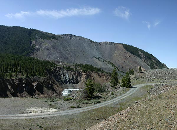
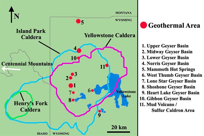
Three separate very large volcanic explosions have occurred in the last 2 million years near Yellowstone. These large geologic events have left calderas that are still visible in some places and numerous thermal features, many of which are still active today. The Henry's Fork Caldera is still visible from the US 20 highway and from above.
![]() This caldera resulted from a large explosion under the hotspot that occurred almost 1.3 million years ago, just as the same pressures were causing the Centennial Mountains to rise.
This caldera resulted from a large explosion under the hotspot that occurred almost 1.3 million years ago, just as the same pressures were causing the Centennial Mountains to rise.
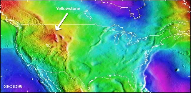
Evidence of this large plume of magma under Yellowstone is found when measuring the earth's Geoid. More than any other measured data set of the earth the Geoid shows us the dynamic structure of it's deep interior. The most dramatic feature in the geoid of North America is this Yellowstone Hot Spot. (See diagram) The geoid is the most graphical representation of the earth's gravity field. The mass of magma under Yellowstone National Park makes this area more dense and thus have a stronger gravity field.
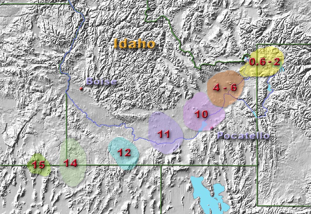
The faults have caused a series of uplifted mountain ranges to appear at a roughly 90 degree angle with the progress of the plate in relation to the hotspot. (see
diagram the dark thick lines represent these faults.)
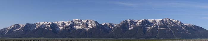
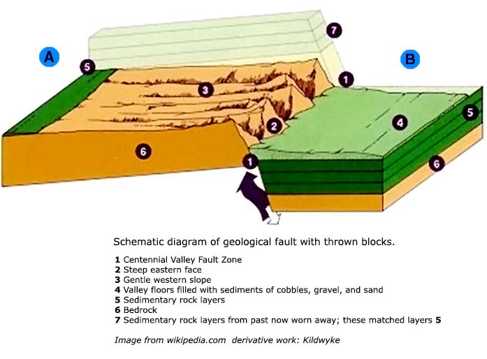
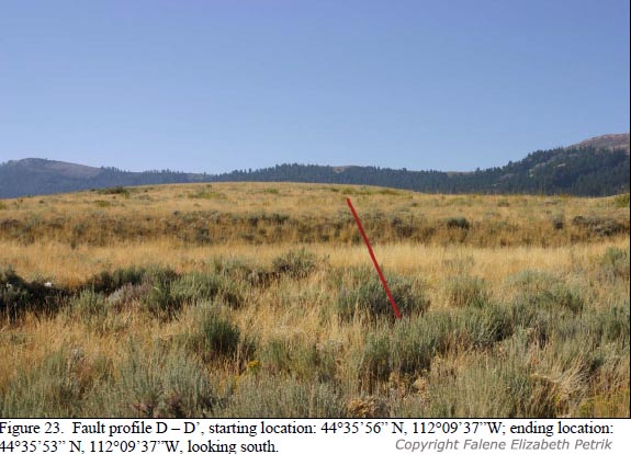
The Centennial Fault lies at the base of the Centennial Mountain range. This fault
can be seen in some places where there are distinct and abrupt differences in topographic height, like a cliff or small hill that rises sharply.
![]() This is the line that marks where the range is rising and the valley is falling.
The eastern Centennial Mountains experienced greater uplift and erosion in contrast to the western Centennial Mountains. This is rather evident when looking at the steep rock faces east of Odell Creek, compared to those from Mount Baldy west.
This is the line that marks where the range is rising and the valley is falling.
The eastern Centennial Mountains experienced greater uplift and erosion in contrast to the western Centennial Mountains. This is rather evident when looking at the steep rock faces east of Odell Creek, compared to those from Mount Baldy west.
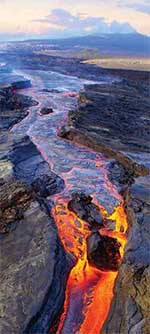
As the earths crust has slowly moved southwesterly over this stationary hotspot or plume, lava erupted over the surface. One such large eruption was the Huckleberry Ridge Eruption , which was the first to happen in the Yellowstone area. About 2.1 million years ago this eruption created lava and ash that settled over the vast area around it, including what is now the Centennial Mountain Range. We know that the uplifting that created the Centennial Mountains started about that time since the very top of the mountains now contain these layers of tuft, which at the time flowed horizontally over the landscape that is now 3000 feet higher. We also know that as the mountains tilted, the valley in front of them was down-thrust almost 9,000 feet. It is now filled with sediments from the erosion over the last 2 million years.
Although there have been no volcanos or volcanic activity in the Centennial Valley within the last 2.5 million years, the uplifting effects of the nearby volcanism and Yellowstone hot spot plume have resulted in the creation of the Centennial Mountains that we see from the Refuge. The lava flows from the nearby Yellowstone volcanic activity prior to the last 200,000 years has created the many lava features seen in the surrounding hills.
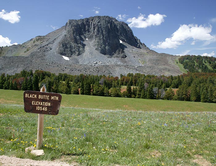
Prior to this, only 15 miles north, in the Gravelly Range, is the nearest example of a much older volcanic structure.
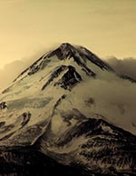
![]() Black Butte is 10,546 feet, the highest point of the Gravelly Range and is estimated to be of early
Miocene origin (20-25 million years old).
Black Butte is 10,546 feet, the highest point of the Gravelly Range and is estimated to be of early
Miocene origin (20-25 million years old).
In summary, a large crustal bulge over a stationary plume of magma that may be reaching as deep as 600 kilometers into the earth's crust, is responsible for the uplifting of the Centennial Mountains. As the North American plate moves southwesterly over this stationary plume mountains are formed by pressures from below as cracks in the earth's crust caused by this bulge are created.
As a comparison to the human evolution timeline, the Centennial Mountains just started to rise as the precursor to man in Africa stepped out of its ape-like forms with the appearance of homo habilis and homo erectus. The modern day form of Homo Sapiens didn't appear until 200,000 years ago.
Continue to glaciation.